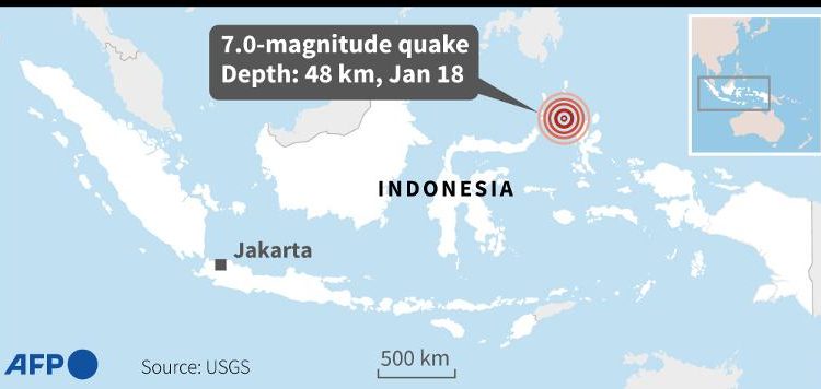
An offshore earthquake with a magnitude of 7.0 hit near eastern Indonesia’s Maluku islands on Wednesday, the US Geological Survey (USGS) reported, triggering a tsunami warning.
The epicentre of the tremor was located 150km (93 miles) northwest of the eastern Indonesian island of Halmahera, at a depth of 48 kilometres.
“Hazardous tsunami waves are possible for coasts located within 300 kilometres of the earthquake epicentre,” the NWS Pacific Tsunami Warning Center in Hawaii said in its warning after the quake.
The quake occurred around 13:06 pm local time (0606 GMT). The quake was revised down from an initial magnitude of 7.2 reported by the USGS.
Indonesia’s Meteorology, Climatology and Geophysics Agency (BMKG) warned of possible aftershocks.
Indonesia experiences frequent seismic and volcanic activity due to its position on the Pacific “Ring of Fire”, where tectonic plates collide.
On November 21, a 5.6-magnitude quake hit West Java province on Indonesia’s main island of Java, killing 602 people.
Most of the victims were killed when buildings collapsed or in landslides triggered by the quake.
A major earthquake off Sumatra on December 26, 2004, set off an Indian Ocean tsunami that killed more than 230,000 people as far away as Sri Lanka, India and Thailand.
That powerful 9.1-magnitude quake triggered 100-foot waves that hit the shore of Banda Aceh on Sumatra.

